Antarctic surveys reveal massive ‘formations’—as tall as the Eiffel tower beneath the ice

Scientists have finally revealed what lies beneath the ice sheet of Antarctica. Surveys reveal massive ‘formations’—as all as the Eiffel tower beneath the ice.
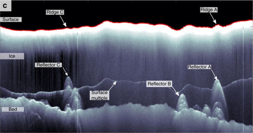
“The most striking features of our observations are large upward disruptions of the ice-bed interface upstream of ice-shelf channels. They are orders of magnitudes larger than the cross-sections of typical subglacial conduits, which are expected to be a few meters in diameter…”
Experts surveyed three predicted water-outlet locations on the ice shelf using airborne radar data, revealing distinct ‘radar reflectors’ below.
Spoiler alert: It’s not ALIENS—or anything similar to that for the matter. ????
Scientists have discovered ‘features’ beneath the Antarctic Ice sheet which are five times bigger than others. These uncanny features are carving deep gashes into the bottom of the ice sheet and play an active role in shaping the ice hundreds of miles away.
Although ancient ice sheets left behind evidence of an hydrological system, modern-day features beneath the ice are difficult to detect b y experts since they are relatively small and hidden thousands of feet below the surface.
However, to the surprise of experts, ‘water conduits’ and ‘sediment ridges’ located beneath the Antarctica Ice sheet have been found to be up to five times larger than others seen in regions where ancient Ice had retreated. According to experts, these features are shaping ice hundreds of kilometers away.
The study—led by scientists from Université libre de Bruxelles (ULB, Belgium) and the Bavarian Academy of Sciences—found that underground channels are wider as they approach the ocean.
Furthermore, as the speed of melt-water slows down as the channel increases in width, sediment deposits accumulate toward the exit causing sediment deposits to build up, creating massive formations—ridges—as large as the Eiffel tower beneath the Ice over the course of thousands of years.
The active sedimentation process gives rise to ‘Eskers—a long ridge of gravel and other sediments, typically having a winding course, deposited by meltwater from a retreating glacier or ice sheet.’
Scientists note: “These obstacles align with predicted hydrological outlets, and thus we interpret them as eskers (sediment ridge composed of gravel and sand) formed by the overlying subglacial water conduits.”
However, experts say that the landforms discovered on the Roi Baudouin Ice Shelf in East Antarctica are much larger than expected. Scientists speculate that these are gigantic ridge-shaped protrusions that cut into the Antarctica Ice, which in turn helps form ice-shelf channels.
Researchers wrote in the study—Published by the Journal Nature Communications:
“Eskers, a glacial landform used in the reconstruction of palaeo-ice sheets, are the depositional evidence of former channelized subglacial hydrological systems. Our inferred eskers are much larger than most eskers of the Wisconsonian glacial record, but, their shape resembles that of some eskers in deglaciated areas formerly occupied by marine-terminating ice sheets.”
Source: Actively evolving subglacial conduits and eskers initiate ice shelf channels at an Antarctic grounding line


 Creators of mankind
 Description of “Tall white aliens”
 Where they came from?
 About hostile civilizations
 The war for the Earth
 “Tall white aliens” about eternal life
 Video: “Nordic aliens”
 Aliens
 Alien encounters
 The aliens base
 UFO
UFO Technology UFO
 Underground civilization
 Ancient alien artifacts
 Military and UFO
 Mysteries and hypotheses
 Scientific facts


